
The Carolinian Life Zone represents less than 1% of Canada’s landmass but is home to the largest diversity of fauna and flora species in the country, as well as the highest number of species at risk.
Three municipalities share the shores of Lake Huron in this area and offer hiking trails through bare and forested dune lands, fresh-water coastal wetlands, rare Oak Savanna, steep and forested ravines in river and creek valleys, remnant prairies of tall grass and wildflowers, spherical concretions or Kettles in black shale beds, and brachiopod and trilobite fossils from the Devonian Period.
Trail Etiquette
Stay on trails and follow the “blazes”, which show turns and endpoints. Don’t litter. Keep dogs on leash. Follow the trail’s uses and activities. Take only photographs and leave only footprints.
THE CRITTER QUIZ - Do You Know Who I am?
Ontario is home to more than 30,000 species. Can you match up the photos of these animals, birds and insects to the right descriptions?
Heaven’s Wildlife Rescue Rehabilitation and Education Centre near Sarnia, Salthaven Wildlife Rehabilitation and Education Centre near Strathroy, and Bluewater Centre for Raptor Rehabilitation provide care and rehabilitation of sick, injured, orphaned, or otherwise compromised wildlife. They rely on donations to return healthy animals to the wild and educate the public on issues affecting Canadian wildlife.
Who Am I?
Match the picture to the critter's description below. Check your answers at the bottom of this article.


Number 1: I am a member of a community thought to be a genetic mutation of the Eastern Grey Squirrel. I use my bushy tail for balance, warmth, and to signal mood. I live in a large leaf nest in a tree. I don’t hibernate. I eat nuts, seeds, fruit, insects, and especially like the buds of maple trees. I use my excellent sense of smell to find where I have hidden food for the winter. I may have two litters of up to six babies each year and live for six years. My kind is important to reforestation.
Number 2: I dig holes other animals use for shelter. When I am not looking after babies or hibernating, I eat and sunbathe. My burrow has a main entrance, spyholes, a bedroom and a bathroom. I hibernate from September to March. I eat wild plants, clover, alfalfa, and garden vegetables (!). Sometimes I eat snails, insects and young birds. My kind can be brown, black or white. I may live for 10 years if I am careful.
Number 3: I am Ontario’s smallest carnivore. I eat mice, chipmunks, birds, rabbits, fish, insects, eggs and frogs. In winter, my coat turns white, and my tail stays black-tipped. I have excellent hearing, sight and smell. I live in a burrow another animal made and decorate with dry grass, leaves, feathers, and fur. I have eight brothers and sisters but live alone. When I speak, I make trills and whistles of greeting and loud, high-pitched squeaking when threatened. My kind lives two years.
Number 4: I have grey fur, small black eyes, a white face, black ears, a pointy nose and a long, scaly tail that can hold things. I sleep during the day and hunt for food at night. I eat worms, insects, grains, fruit, grass, carrion, snakes, and eggs. I can eat 5,000 ticks in a season. I live in damp woodlands near water and am Canada’s only marsupial. I have up to 25 babies in a litter. I have 50 teeth, the most of any North American mammal and play dead if scared.
Number 5: I eat voles, mice, squirrels, rabbits, birds and eggs. Sometimes I catch Lake Trout. I bury extra food for later. I have excellent hearing, sight and smell. I can hear a mouse move underground and smell rabbits’ nests hidden in the grass. I live in thickets and heavy bush, but make a den from another animal’s burrow when I have kits in the spring (March-May). I speak using sharp barks.
Number 6: I dig my burrow in forests, under rocks and fallen trees and live in the same one for several years. I store nuts and seeds under bedding of leaves and grasses. My cheek pouches expand three times the size of my head to hold food, like fruits, nuts, seeds and mushrooms. Sometimes I eat birds’ eggs and worms. My cheek pouches get bigger with age. I do not hibernate; I sleep a lot and wake up for snacks every few days or weeks. I have 3 to 5 babies in a litter who venture from the burrow after six weeks. I can live for five years.
Number 7: I winter in Florida and Mexico like other Canadians. I am an egg, then a stripy caterpillar, then a green chrysalis, then a beautiful butterfly with stained glass-like wings. Milkweed is essential because it is the only food I eat when I am a caterpillar and where I lay my eggs when I am a butterfly. I am an important pollinator. Because I eat milkweed, I am poisonous to eat for many birds, other than robins, orioles, grosbeaks, grackles, cardinals, sparrows, and jays. I live up to 32 days. When I migrate, it will be my great-grandchildren that return.
Number 8: I make a home using my beak by chipping out an oblong hole of 10 to 24 inches deep in a dead tree. This can take six weeks. I use this nest for a season and find other birds move in after I have left. Striking dead trees and fallen logs, I make deep holes in the wood where I find my favourite foods, carpenter ants, beetle larvae and termites. I also like flies, caterpillars, cockroaches, grasshoppers, wild fruits and nuts, but I will visit your backyard for suet! You can tell I am a male because I have a red cheek stripe. The oldest of my kind has lived to 12 years.
Number 9: I am a large, majestic bird, weighing only 5 lbs (2.5 kg). I eat fish, frogs, reptiles, small mammals, insects, and birds. I have night vision to hunt for food at night, not just during the day. I prefer to nest in trees but can make do on the ground or in bushes. Building a nest takes two weeks, and I will have three to five eggs in April. My kind is found year-round in North America, although typically only from spring to fall in Canada. I clean my feathers by combing them downwards with the claw of my middle toe. I may live 17 years.
Number 10: I am a reptile and have “cold-blood” that matches the temperature of my surroundings. I am the largest freshwater turtle in Canada. My scaly skin allows me to live out of water, and I have a long spiked tail. My shell has a back carapace and a belly plastron of bony plates. Unlike other turtles, I cannot pull my entire body inside my shell. I eat water plants, worms, snails, fish, frogs, snakes, small turtles, water birds and freshly dead animals. When I am 17, I will lay eggs in loose, sandy soil at the shoreline, an embankment or side of a road. I hibernate in winter, burying myself in sand or mud in the river or lakebed not far from shore. I can live 70 years.
Sources: https://natureguelphtracking.wordpress.com/, Ontario Ministry of Natural Resources, Canadian Geographic, Hinterland Who’s Who, www.allaboutbirds.org
Answers: 1. White Squirrel (F), 2. Groundhog (H), 3. Short-tailed Weasel (A), 4. Opossum (D), 5. Red Fox (B), 6. Chipmunk (J), 7. Monarch Caterpillar (G), 8. Male Pileated Woodpecker (E), 9. Great Blue Heron (I), 10. Snapping Turtle (C).
LAMBTON SHORES NATURE TRAILS
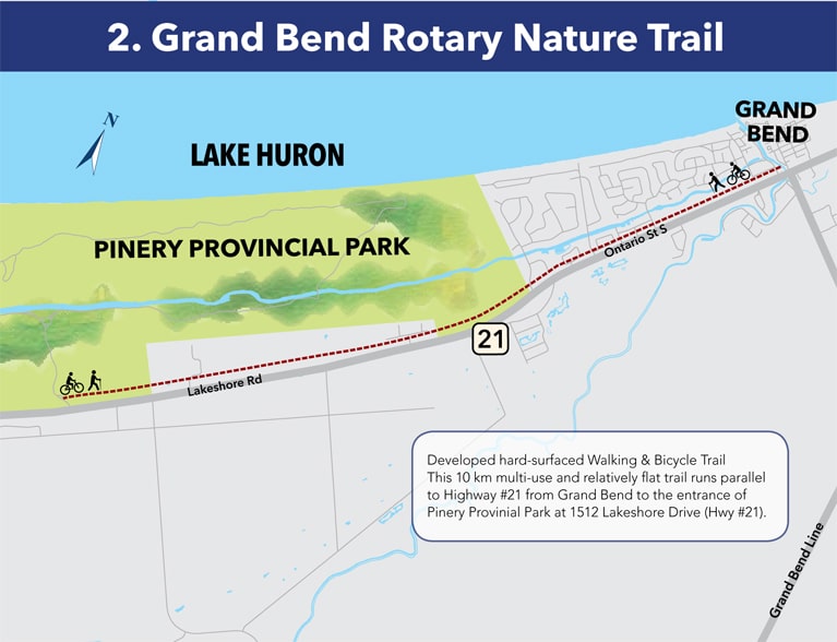
Grand Bend Rotary Nature Trail (Grand Bend)
Asphalted 9 km walking and cycling trail alongside Highway 21 from Grand Bend to the Pinery Provincial Park entrance. Click to view Grand Bend Rotary Trail map .
Esli Dodge Conservation Area (Forest)
20 acre conservation area (part of the St. Clair Region Conservation Authority) with man-made lake (no swimming). Access at 88 Main Street. Portable washrooms May to October. Playground, picnic area, tennis courts, paved walking/cycling paths, gazebo. The island in the lake acts as a stage for theatrical and musical performances during the summer and the hillside opposite seats 6,000 people. Home to Forest’s Canada Day Celebrations. scrca.on.ca Click to view map of Esli Dodge Conservation Area.
Forest Trail System (Forest)
Access from Rotary Civic Square. Asphalted 2.8 km walkway leads south to Esli Dodge Conservation Area. The trail along the Old Railway Track and around lagoons west of Forest offer 4.5 km return trip over flat lands. Click to see map of Forest Trail System.
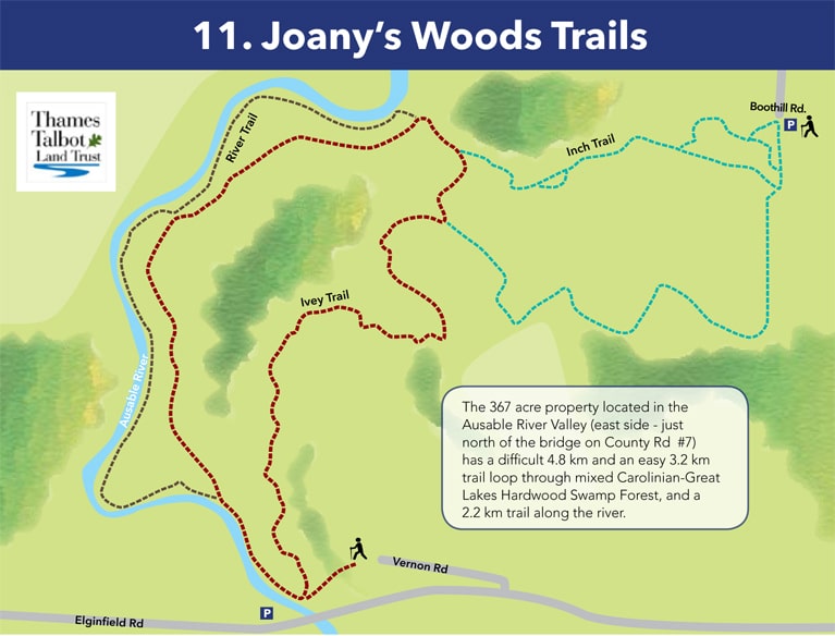
Joany’s Woods Trail (Sylvan)
367 acres in the Ausable River Valley offers a challenging 4.8 km trail and an easy 3.2 km trail through mixed Carolinian and Great Lakes Hardwood swamp forest, and a 2.2 km trail along the river. Two access points: (1) Drive east on Elginfield Road from Sylvan, turn right onto Vernon Road; (2) Drive north from Sylvan on Sylvan Road, turn left onto Elliot Road and right onto Boot Hill Road, watch for signage. Trailhead and On-trail signs; trail guide available.
Click to see map of Joany's Woods Trails.
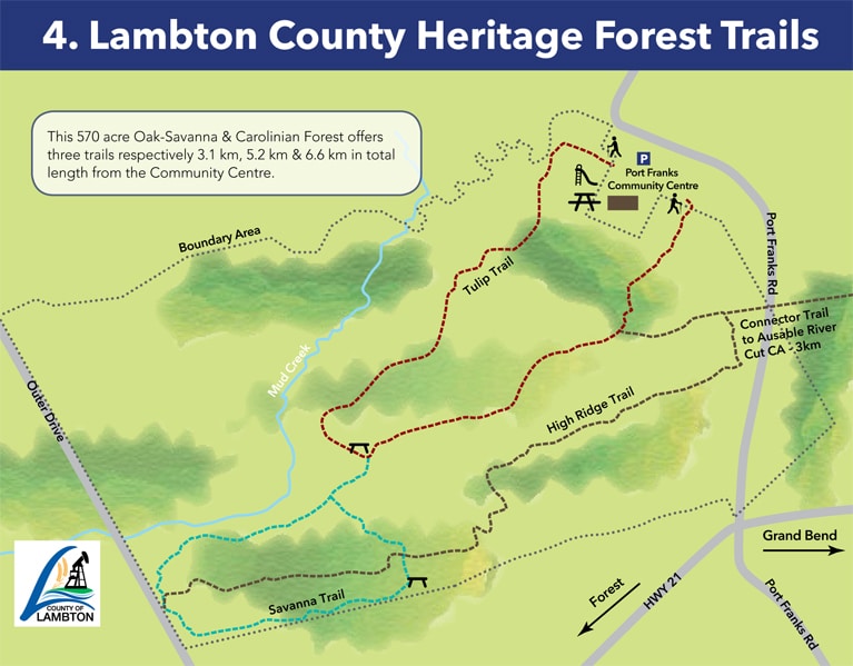
Lambton County Heritage Forest (Port Franks)
Hiking and mountain-biking trails in 570 acre Oak-Savannah and Carolinian forest. Access from Port Franks Community Centre, 9997 Port Franks Road. Offers three trails: 3.1 km, 5.2 km and 6.6 km. Trailhead and On-Trail signs.
Click to see map of Lambton County Heritage Forest Trails.
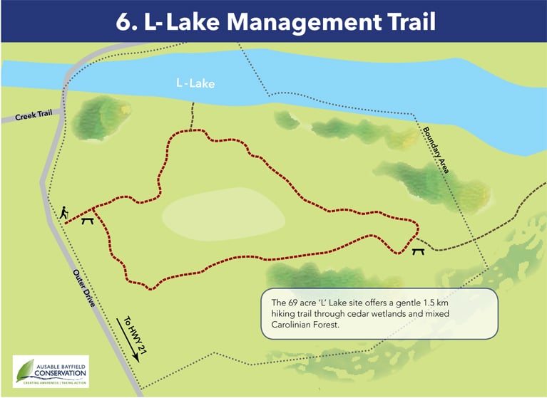
L-Lake Management Area (Port Franks)
69-acre area offers 1.5-kilometre trail through cedar wetlands and mixed Carolinian forest. Access at 7101 Outer Drive. Trailhead sign.
Click to see map of L-Lake Management Trail.
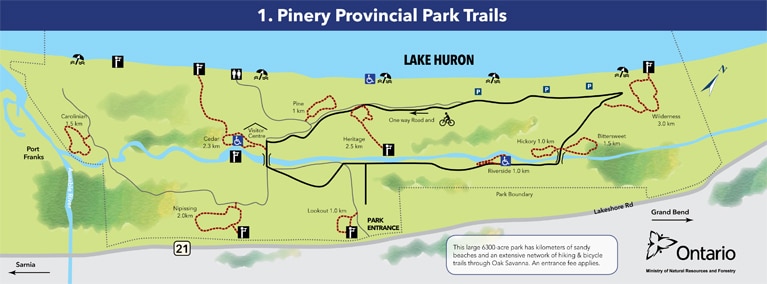
Pinery Provincial Park (Grand Bend)
6,300 acres of Oak Savanna, Carolinian woodlands and Freshwater Coastal Dune ecosystem. Home to endangered plants, animals and insects. Extensive nature trails and 13 km asphalted, close-loop bike path. Bike and helmet rentals (mountain, coaster, tandem, kids, child trailers & helmets). Wheelchair accessible trails and two beach-friendly wheelchairs available for use. pinerypark.on.ca/trails
Click to see map of Pinery's Trails.
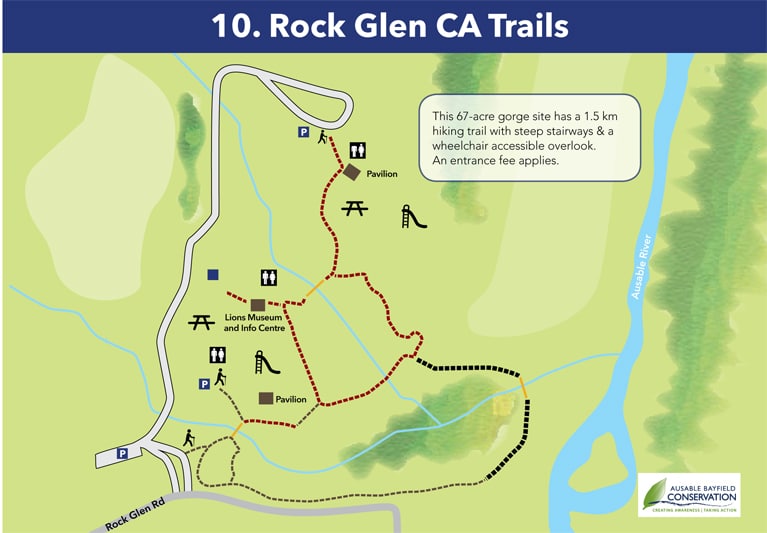
Rock Glen Conservation Area (Arkona)
Home of Lambton County’s ONLY WATERFALL. Plunge your hand in the water and grab some pebbles – it’s likely you’ll find a brachiopod, crinoid or gastropod fossil! Stairs, boardwalks and bridge allow visitors to explore the glen’s steep sides and 10.7-metre high waterfall. Scenic lookouts, picnic area, BBQs, pavillions, museum, washrooms and two playgrounds. Drive north of Arkona on Arkona Road (County Rd. 79), turn right on Rock Glen Road, watch for signage. abca.on.ca
LAMBTON SHORES NATURE TRAILBLAZERS
Lambton Shores Nature Trailblazers
Lambton Shores Nature Trails (LSNT) was founded in October 2011 by a group of local nature and hiking enthusiasts alarmed by the ongoing destruction of environmentally significant natural areas by trespassing ATVs and dirt bikes.
To save these natural areas, LSNT partnered with landowners to provide fun and free public access to hiking trails, bike paths and water routes. LSNT has built a network of user-friendly nature trails that inspire people to experience the biodiversity of Lambton Shores and Vicinity.
This year marks the volunteer group’s 10th Anniversary. To celebrate they have created a set of four commemorative stitched patches highlighting some the most scenic and memorable locations: Lambton County Heritage Forest, Ausable River Valley & Mystery Falls, Ipperwash Dunes & Swales and the L-Lake Management Area.
The commemorative set is available for $20. Contact Linda Attard to get your set today! lsntlindaa@gmail.com / 519-243-1596
![]()
![]()
![]()
![]()
DISCOVER THE TEACHINGS! INDIGEONOUS ART AT TRAILHEADS
 Discover the artwork of Kettle & Stony Point indigenous artists Garrett Nahdee and Jeff George on the trails of Lambton Shores. Nahdee's carved wooden sculptures representing the teachings of the Seven Grandfathers - Love, Respect, Courage, Wisdom, Truth, Humility and Honesty - surround the Circle of Life at the Port Franks Community Centre. Meanwhile, trailhead structures proudly display large-scale reproductions of George's beautiful paintings that reflect the teachings and traditions of the Anishinaabe people.

BLUEWATER TRAILS
The following information is courtesy of the Bayfield River Valley Trails Association (bayfieldtrails.com), the Ausable Bayfield Conservation Authority (abca.on.ca) and Friends of Hullet Marsh (hullettmarsh.com).
Bannockburn Conservation Area (Brucefield)
Year-round, 62 acre conservation area with wet meadows, eastern white cedar forest, deciduous forest, old field and mixed scrub and marsh. Main trail leads from the parking. The first 500 m consists of accessible boardwalks over river and creek; balance of trails feature hilly terrain with few stairs or boardwalks. Access at 76249 Bannockburn Line, between Brucefield and Bayfield.
Bayfield River Valley Trails (Bayfield):
Heritage Trail
Follow Pioneer footsteps through Bayfield on an easy 2 km stroll along tree-lined streets, passing heritage buildings. (bayfieldtrails.com/heritage-trail)
Mavis Trail
Four season 2.5 km challenging looped trail to Bayfield River and back. Access from Stanley Recreation Complex, 38572 Mill Rd., Varna.(bayfieldtrails.com/mavis-taylor-trail)
Sawmill Trail
Access the 1.67 km woodland and riverside trail from highway 21, turn east onto Old River Road, then right onto Sawmill Road, watch for signage. Varied terrain changes from flood plain to coniferous forest and hillsides. (bayfieldtrails.com/sawmill-trail)
Taylor Trail
1-km looped easy walk through flat terrain, suitable for wheelchairs. Access from Stanley Recreation Complex, 38572 Mill Rd., Varna.
Woodland Trail
Medium difficulty, 5 km trail meanders along village roads, dips into woods and follows old gravel pit and lumbering roads and deer paths. Access at Keith Crescent and Hill Terrace. (bayfieldtrails.com/woodland-trail)
Hullett Provincial Wildlife Area (Clinton)
5,420 acres along the South Maitland River and located on the paths of two major waterfowl flyways (Atlantic & Mississippi). Seven trails from 0.4 km to 4.6 km, featuring grassland, wetland and wooded terrain. Activities include hiking, horseback riding, seasonal hunting, canoeing, snowmobiling, and geocaching. Multiple parking lots and access points. Refer to hullettmarsh.com for hiking map and information.
SOUTH HURON TRAILS
Morrison Dam, MacNaughton Park & South Huron Trail (Exeter)
10 km round-trip hiking trail from the Morrison Dam westwards along the Ausable River to Exeter’s MacNaughton Park. Hiking, cross-country skiing, birding and wildlife watching and fishing. Picnic areas and washrooms. Access from Exeter’s Main Street by the river or drive east of Exeter on County Road 83, turn south on Morrison Line, and watch for signage. abca.on.ca
GEOCACHING & HANDY WEBSITES
Geocaching & GIS Trail Mapping
Geocaching is like a high tech scavenger hunt in which participants use a Global Positioning System (GPS) unit or mobile device to search for “geocaches”. Download cache locations from geocaching.com. GPS units available at Northville Municipal Office, 9575 Port Franks Rd., Thedford, 519-243-1400. Huron County’s hiking guide is available at the Welcome Centre in Grand Bend or hikehuron.ca.
Handy Websites
- Ausable Bayfield Conservation Authority: abca.on.ca
- Bayfield Trails: bayfieldtrails.com
- Hullett Provincial Wildlife Area: hullettmarsh.com
- Lambton Shores Nature Trails: lsntblazers.com
- Lambton County Trails: lambtoncountytrails.com
- Maitland Valley Conservation Authority: mvca.on.ca
- Clair Region Conservation Authority: scrca.on.ca